Enregistrez gratuitement cette image
en 800 pixels pour usage maquette
(click droit, Enregistrer l'image sous...)
|
|
Réf : V01774
Thème :
Terre vue de l'espace - Déserts - Dunes (200 images)
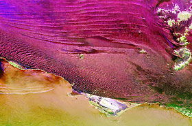
Titre : Space Radar Image of Namibia Sand Dunes
Description : (La description de cette image n'existe qu'en anglais)
This spaceborne radar image shows part of the vast Namib Sand Sea on the west coast of southern Africa, just northeast of the city of Luderitz, Namibia. The magenta areas in the image are fields of sand dunes, and the orange area along the bottom of the image is the surface of the South Atlantic Ocean. The region receives only a few centimeters (inches) of rain per year. In most radar images, sandy areas appear dark due to their smooth texture, but in this area the sand is organized into steep dunes, causing bright radar reflections off the dune 'faces.' This effect is especially pronounced in the lower center of the image, where many glints of bright radar reflections are seen. Radar images of this hyper-arid region have been used to image sub-surface features, such as abandoned stream courses. The bright green features in the upper right are rocky hills poking through the sand sea. The peninsula in the lower center, near Hottentott Bay, is Diaz Point; Elizabeth Point is south of Diaz Point.This image was acquired by Spaceborne Imaging Radar-C/X- Band Synthetic Aperture Radar (SIR-C/X-SAR) onboard the space shuttle Endeavour on April 11, 1994. The image is 54.2 kilometers by 82.2 kilometers (33.6 miles by 51.0 miles) and is centered at 26.2 degrees South latitude, 15.1 degrees East longitude. North is toward the upper left. The colors are assigned to different radar frequencies and polarizations of the radar as follows: red is L-band, horizontally transmitted and received; green is L-band, horizontally transmitted, vertically received; and blue is C-band, horizontally transmitted, horizontally received. SIR-C/X-SAR, a joint mission of the German, Italian, and United States space agencies, is part of NASA's Mission to Planet Earth.
|
|

